City of Fort Worth Flood Risk Mapping
Engineered Solutions: City of Fort Worth Flood Risk Mapping
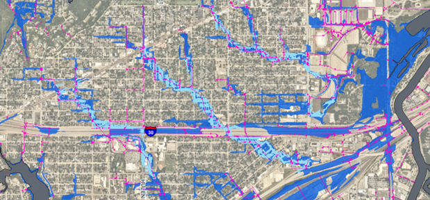
Texas is known for its record-breaking temperatures and droughts. However, in August 2022, the Dallas-Fort Worth Metroplex experienced historic amounts of rainfall. Pape-Dawson’s Zubin Sukheswalla, P.E., CFM, watched closely as streets turned into rivers. Since January 2022, he and his Team Lead, Mr. Lonnie Anderson, P.E., CFM, had been mapping urban flood risk for the City of Fort Worth. In August 2022, their mapped urban flood risk and drainage patterns closely matched reports of flooding in and around the city. This proved that the standardized approach developed by Pape-Dawson for the entire City represented true urban flood risk in different parts of the City.
To develop urban flood risk on a large scale like the 950+ square miles of the city, Mr. Anderson used the Hydrologic Engineering Center – River Analysis System (HEC-RAS) software developed by the U.S. Army Corps of Engineers. The software is widely popular, is free to access, and has a huge user community providing cities, counties, and other public and private agencies with significant savings over costly software alternatives that require specially trained individuals to purchase, run, and maintain. The result is that the Pape-Dawson team developed citywide urban flood risk mapping with storm drain approximations for the 1-, 5-, and 100-year in approximately 4 months. That’s a fraction of the time it would take using other proprietary software at this scale. Our team’s results (shown below) closely matched areas of the city already studied with this proprietary software, showing great promise in the concept of utilizing HEC-RAS for efficient urban flood risk mapping at a large scale.
Pape-Dawson’s innovative and unique application of HEC-RAS technology is two-fold . First, the software has traditionally been used to measure surface flow, but Mr. Anderson and the team adapted it to include subsurface flow (storm drains) on such a large scale. Secondly, to capture urban flood risk at the street level while keeping run times manageable, the team split the city into 17 watersheds using a 50’ cell size. The result is a cost-effective, scalable, sharable, user-friendly process for identifying both riverine and urban flood risk on a citywide scale.
Since HEC-RAS is a FEMA-accepted software, this approach allows for flood risk determination in areas not currently mapped by FEMA . It is in these unmapped areas that most people live and work, and yet these areas are the ones that remain predominantly unmapped for flood risk. In the coming months, this new mapping will be available to Fort Worth citizens through the City’s non-FEMA flood risk website and dedicated Flood Risk Viewer. Users can enter an address and learn whether the threat to their property is minor, major, or extreme. This tool will provide local homeowners and businesses with valuable insight into urban flood risk for their properties allowing them to plan ahead of major storm events like the one on August 22, 2022.
Unique challenges call for unique solutions, and Pape-Dawson’s Stormwater team is proud to have developed an innovative engineering approach that was not only cost-effective but also delivered valuable urban flood risk information that is greatly needed by the City of Fort Worth.