The statement “When it Comes to Flood Risk, Knowledge is Power” highlights the crucial role that information plays in managing and mitigating the impact of floods. In areas prone to flooding, such as Harris County, Texas, being well-informed about flood risk is essential for individuals, businesses, and local governments. Hurricane Harvey famously devastated Houston in 2017, but heavy rains have often wrought destruction across the area before and since. In fact, a major flood hits the county about every two years.
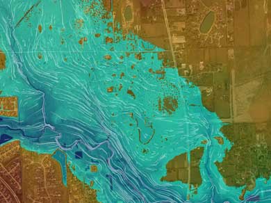
Enter the MAAPnext (Modeling, Assessment and Awareness Project) program, led by Harris County Flood Control District (HCFCD) in conjunction with FEMA. The project integrates historical storm data, topographic information, new 1D/2D hydraulic modeling, and information from impervious coverings, land use, and completed flood damage reduction projects—and allows users to reliably predict the flood risk for particular addresses.
Pape-Dawson played a crucial part in creating the MAAPnext product as a member on the Program Management Team as well as the prime consultant on 3 out of 23 countywide watersheds. “Our role was to calibrate hydrology and hydraulics against historic events and develop updated watershed-wide FEMA models and mapping at a higher level of detail than previously possible,” said Lonnie Anderson, P.E., CFM, who served as Pape-Dawson’s Project Manager.
How is this a leap forward from solutions in the past? “The advantage of 1D/2D modeling is that the model shows where flood flows occur versus engineers dictating flow assignments, reducing the potential for errors,” Lonnie says. “It allows for fast ‘what if’ scenarios and improved quantification and presentation of flood risk through time and aerial extent.”
Flood risk data can play a major role in the decision-making process for individual families, businesses, and local governments. The program provides the benefit of knowledge to families considering where to buy a home as well as business owners as they seek out future brick-and-mortar locations. The implications around flood insurance and government planning are significant, too. Local governments can utilize the data to prioritize projects and inform decisions on infrastructure improvements. It’s encouraging to see technology being used to empower communities with crucial flood risk information, allowing for better-informed decision-making.
“MAAPnext represents a transformative approach in the management and regulation of floodplains with the goal of providing communities with much-needed flood risk information quickly,” said Lonnie. Ready to play with this new technology yourself? Just go to the MAAPnext site to see how it works!