by Lonnie Anderson, P.E., CFM, Practice Leader in Hydrology & Hydraulics
As another hurricane season begins, a headline about flood risk in Harris County is nothing new.
By now, Houstonians know the drill: “Turn Around, Don’t Drown” reminders begin to pop up along morning commutes; we run through survival kit checklists (Water? Nonperishables? Batteries? Nearest evacuation route?); and we become more diligent in checking weather forecasts. And yet, despite years of experience and preparation, a majority of those in Harris County are still missing one crucial step: protecting their property with flood insurance regardless of whether or not it is located within a 100-year floodplain.
The reality, according to new data, is that when intense rains occur within Harris County, it can, and will, flood, and Houstonians need to be prepared. As Practice Leader in Hydrology & Hydraulics at Pape-Dawson Engineers, I lead a team that is working with the Harris County Flood Control District and FEMA jointly funded Modeling, Assessment, and Awareness Project (MAAPnext), an initiative to generate more accurate floodplain maps for Harris County which will arguably be the most detailed in the country. My team, along with 7 other consultant teams are in charge of developing and testing the models and methodologies used by MAAPnext to capture flood and rainfall data across the county in more precise detail than ever before.
Many hold the general assumption that if they are not located within a floodplain, they do not need flood insurance. But what may surprise Houstonians is that more than 60 percent of flood claims filed in Harris County are outside of the mapped floodplain. Historically, floodplain maps only included areas that were at risk of flooding from a primary water source such as channels, rivers and bayous. They did not take into account other factors that can affect flooding during unexpectedly heavy rainfall, like minor streams with low stormwater-carrying capacity or areas without adequate stormwater drainage. Rain during Hurricane Harvey fell faster than our low-lying terrain could handle, and the existing maps didn’t hold up.
The good news is that Harvey and other historical storm data is helping us better prepare for future events. Today new technologies allow us to paint a more vivid, realistic picture of flood risk in the region. The National Oceanic Atmospheric Administration’s Atlas 14 study (2018), which examined historic rainfall depth, duration and frequency in Texas, shows rainfall during a typical 100-year event in Harris County has increased by nearly 30% since the last mapping study that was completed in 2007, rendering previous 100-year and 500-year storm boundaries obsolete. This more comprehensive, up-to-date precipitation data will allow us to redefine flood zones to reflect current totals.
Additionally, we have developed new modeling methodologies for the MAAPnext project, including an improved method to analyze sheet flow (or storm runoff that flows over the ground at shallow depths and does not concentrate in channels). Our model tells us where the flow is going and at what rate, helping us identify previously unrecognized areas that have a high risk of flooding.
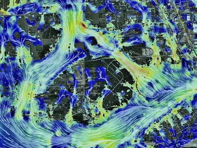
Light Detection and Ranging, or LiDAR technology, has also improved since the last floodplain mapping effort in 2001. LiDAR is a surveying method that uses light in the form of lasers to examine the surface of the earth and measure distance. Captured data is then used to generate three-dimensional maps of an area. Technological advances mean that LiDAR data collected today provides 25 times greater detail in the terrain data used for the development of hydraulic models and mapping of floodplains than the previous 2007 mapping. This has especially significant ramifications for Houston, which is mostly flat. Improved terrain definition allows for better data capture of overflow outside of the expected channels, which can then be incorporated into new models and mapping.
Together, these new technologies and methodologies enable us to capture data more accurately than before and will help guide the region’s future flood resistance and resiliency. We can identify truer flood elevations and better replicate where flood waters originate and flow, helping us identify previously unmapped flood risk of major rain events. Additionally, this modeling will better maximize the benefit of future flood reduction projects and help us avoid unforeseen impacts of development in the region.
In the long term, the goal of all of this new data and 21st-century flood risk mapping is to enable governing agencies to improve drainage on a broad scale, reducing potentially major damage to Houstonians homes each time it rains. But in the short term, the insights we’ve gleaned make one thing clear: every Houstonian should have flood insurance.
For more information about MAAPnext, visit www.maapnext.org.
Download the article here: Do All Houstonians Really Need Flood Insurance?